


وصف لـ Satellite Locator
Finding a TV satellite, in azimuth, can be pretty difficult. With this app you do not need a compass, just two (2) GPS locations, from the satellite dish and a target, is enough. Finding the satellite depends on how accurate the GPS locations are (the phone or from Google Earth/Maps) and how accurate and steady you can aim the phone to the target. Read more about the WARNING and how it works.
WARNING: when you are close to or in between walls, roofs, sheds, trees, houses, flats or close to metal the phone's GPS location can be totally wrong which will result in a faulty satellite position !! Your satellite dish and target should be preferably in an 'open space'.
How does it work ? In 3 steps or screens:
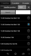
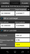
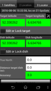
1- Select the desired TV satellite
2- The GPS location of the satellite dish and the GPS location of a target (or reference point) is needed. The target can be the GPS location of a house, tree, plant, etc. Just enable the GPS in your phone or enter the GPS locations with the help of Google Earth/Maps (satellite dish position and a visible target position).
To indicate how stable or good the values are they get a color. RED = not good or not stable, YELLOW = better but not good, GREEN = good or stable, CYAN = don't know. To receive good GPS signals you should be in the 'open'. GPS signals can be blocked by buildings, trees, etc and that will result in false GPS locations with an error of several meters while the accuracy is good.
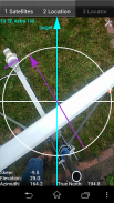
3- Set the dish elevation and skew to the calculated values, see screen 3. The satellite pole must be upright. With the GPS locations set, hold the phone steady above the satellite dish and aim the central arrow named 'target' at the target. Then aim the satellite arm to the arrow named 'satellite'. The success of finding the satellite depends on the accuracy of the phone's GPS and how steady your hands are. KEEP THE PHONE AIMED STEADY AT THE TARGET !!!
Check my instruction movie on
www.youtube.com (https://youtu.be/o7t9cTVfr1A) or
at http://home.caiway.nl/~fnijhuis/satloc/index.html .
When your phone crashes: stop running app's like: Facebook, Twitter, Whatsapp, Badoo, etc. Free up memory of the phone by removing apps you do not use, remove photos and music.
The satellite positions are derived from Agi's database.
Some positions may seem not accurate (example: Hispasat 30°w is at 29.96°w in the satellite list) but they are very accurate.
If you have any questions, requests or problems PLEASE write an email.
This app is add-free !
Help me to continue the work on this app and watch some of my videos on Youtube. The advertising in the videos provides some required money (hours of work, phones to test on, satellite equipment, etc.).
All language translations by Google Translator.
العثور على القنوات الفضائية، في السمت، يمكن أن يكون صعبا جدا. مع هذا التطبيق لا تحتاج بوصلة، اثنين فقط (2) GPS المواقع، من طبق الأقمار الصناعية، والهدف، ويكفي. العثور على قمر صناعي يعتمد على مدى دقة المواقع GPS هي (الهاتف أو من جوجل الأرض / خرائط) ومدى دقة وثابتة يمكنك تهدف الهاتف إلى الهدف. قراءة المزيد عن تحذير وكيف يعمل.
تحذير: عندما كنت قريبة أو بين الجدران والسقوف، حظائر، والأشجار والمنازل والشقق أو قريبة من معدن موقع GPS الهاتف يمكن أن تكون خاطئة تماما الأمر الذي سيؤدي في موقف الأقمار الصناعية الخاطئ !! وينبغي أن يكون طبق الأقمار الصناعية والهدف ويفضل أن يكون في "مساحة مفتوحة".
كيف يعمل ؟ في 3 خطوات أو الشاشات:
1- حدد القنوات الفضائية المطلوب
2- الموقع GPS من طبق الأقمار الصناعية والموقع GPS من الهدف (أو نقطة مرجعية) هو مطلوب. الهدف يمكن أن يكون الموقع GPS من المنزل، شجرة، والنبات، وما إلى ذلك فقط تمكين GPS في الهاتف أو دخول المواقع GPS مع مساعدة من جوجل الأرض / خرائط (موقف طبق الأقمار الصناعية ووضع هدف واضح).
للإشارة إلى مدى استقرار أو جيدة القيم هي التي تحصل على اللون. RED = يست جيدة أو غير مستقر، أصفر = أفضل لكن ليست جيدة، أخضر = جيد أو مستقر، سماوي = لا أعرف. لاستقبال إشارات نظام تحديد المواقع الجيدة يجب أن تكون في 'فتح'. إشارات نظام تحديد المواقع يمكن أن يكون قد تم حظره من قبل المباني والأشجار وغيرها، والتي من شأنها أن تؤدي إلى مواقع GPS كاذبة مع وجود خطأ من عدة أمتار في حين أن دقة جيدة.
3- تعيين الارتفاع طبق وتحرف إلى القيم المحتسبة، انظر الشاشة 3. يجب أن يكون القطب الفضائية تستقيم. مع مجموعة المواقع GPS، أمسك الهاتف ثابتة فوق طبق الأقمار الصناعية وتهدف السهم مركزيا يسمى "هدف" في الهدف. ثم الهدف الذراع الأقمار الصناعية إلى السهم اسمه 'الفضائية'. نجاح العثور على القمر الصناعي يعتمد على دقة تحديد المواقع الهاتف، وكيف ثابتة يديك. الحفاظ على الهاتف الهادفة ثابتة في الهدف !!!
تحقق فيلم تعليماتي على
www.youtube.com (https://youtu.be/o7t9cTVfr1A) أو
في http://home.caiway.nl/~fnijhuis/satloc/index.html.
عندما تعطل هاتفك: وقف تشغيل في التطبيق مثل: الفيسبوك، تويتر، واتس اب، Badoo، الخ تحرير الذاكرة من الهاتف عن طريق إزالة التطبيقات التي لا تستخدم، وإزالة الصور والموسيقى.
وتستمد مواقف الأقمار الصناعية من قاعدة اجي و.
قد تبدو بعض المواقف غير دقيق (على سبيل المثال: هيسباسات 30 ° w غير في 29.96 ° ث في قائمة الأقمار الصناعية) لكنها دقيقة جدا.
إذا كان لديك أي أسئلة أو طلبات أو مشاكل يرجى إرسال بريد إلكتروني.
هذا التطبيق هو خال من إضافة!
تساعدني على مواصلة العمل على هذا التطبيق ومشاهدة بعض أشرطة الفيديو الخاصة بي على موقع يوتيوب. الإعلان في أشرطة الفيديو يوفر بعض المال المطلوب (ساعات العمل، وهواتف لاختبار على معدات الأقمار الصناعية، وما إلى ذلك).
كل الترجمات اللغة عن طريق مترجم جوجل.
Satellite Locator - إصدار 0.7.2
(18-12-2023)Satellite Locator - معلومات APK
نُسخة APK: 0.7.2الحزمة: zekitez.com.satelliteestimatorتطبيقات من الفئة نفسها
قد يعجبك أيضًا...


